
Galiñeiro Mountain PR-G1 route
Climb onto Vigo’s roof
The Galiñeiro Mountain PR-G1 route is one of the most interesting because it runs through Vigo’s highest mountain. Located near the border with Gondomar and O Porriño, it’s very easy to access the base and then surround it. This is an ideal route for hiking with friends or your couple, both for the views and the route itself.
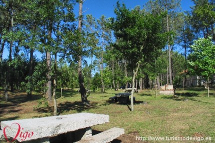
To get to the starting point, you take the Vigo-Gondomar PO-330 road or the highway to Val Miñor AG-57. Once in the A Pasaxe industrial park, located a few meters off the PO-330 towards Gondomar, this route crosses the highway at a different level. Just after the crossing, on your left, you’ll find the beginning of the Galiñeiro Mountain PR G1 trail. It ascends slightly towards a quarry and then runs down into a spacious landing with a fountain and a brook. It's common to find wild cattle here and you can also enjoy the flight of the birds of prey that inhabit this area.
From the rest area and forest park you’ll see the top of the mountain and the ascending route, first gently and progressively steeper as it reaches its end. The view of the landscape at the top is really worth the climb, you can see Vigo’s entire metropolitan area. You can also avoid the final ascent by going around on the left, at an equally remarkable height but on a dirt road that surrounds the most difficult part of mountain.
The trail descending Galiñeiro PR G1 Mountain is on the opposite side, gradually turning to the left. After reaching the base, the route continues down to Zamáns River, in the vicinity of its reservoir, where you’ll see several mills, such as As Maquías, and other ethnographic elements. Once in the area along the river, just head towards the Vigo-Gondomar PO-330 road and walk back down just over a mile to return to the starting point.
The Federación Galega de Montañismo (Galician Mountain Climbing Federation) offers maps and detailed information.
The final section when ascending to the top of the mountain is more a trekking trail than a hiking trail.
There are also several areas near the top where you can practice climbing.
Practical information
Distance: 5 miles.
Duration time: Three hours.
Difficulty: Medium-high.
Type of route: Circular.